
Where is Sicily on a map of Italy?
Look at the toe of the Italian boot: Sicily is the big island just off it, so close that on most maps it looks as if the toe is about to kick it. The narrow channel between them is the Strait of Messina, which Britannica puts at about 2 miles (3 km) wide at the northern end, widening to about 10 miles (16 km) in the south.
Car ferries cross it from Villa San Giovanni, on the tip of Calabria, to Messina, and even the trains from Rome are shunted onto a ferry to get across. No bridge crosses it yet; my guide to the Messina Strait bridge explains the plan.
Politically Sicily is one of Italy's twenty regions, an autonomous one with its own statute, and Palermo is its capital. If you are wondering whether that makes it a separate country (it doesn't), I answer that in Is Sicily part of Italy? For getting here by land and sea from the mainland, see getting to Sicily from Rome and Naples.
Sicily on a map of Europe
On a map of Europe, Sicily sits at the very bottom of Italy, in the middle of the Mediterranean, closer to Africa than most people expect. Britannica puts it about 100 miles (160 km) northeast of Tunisia, and Malta lies about 58 miles (93 km) to the south. The sea to its north is the Tyrrhenian, to its east the Ionian, and between Sicily and Tunisia runs the Strait of Sicily, which joins the eastern and western halves of the Mediterranean.
That position explains a lot of its history: Greeks, Carthaginians, Romans, Arabs, Normans and Spaniards all wanted the island that sits on the sea lanes between Europe and Africa. My guide to Sicily's history tells that story.
How big is Sicily compared to a US state?
The region of Sicily, smaller islands included, covers 9,974 square miles (25,832 km²) according to ISTAT, which makes it the largest region in Italy. That is very close to the size of Vermont or Massachusetts:
| Place | Area |
|---|---|
| New Hampshire | 9,349 sq mi |
| Vermont | 9,616 sq mi |
| Sicily (the region) | 9,974 sq mi (25,832 km²) |
| Massachusetts | 10,554 sq mi |
| Maryland | 12,406 sq mi |
Size on a map is misleading, though, because the roads are slower than American ones: the island is mountainous inland, and many of the most beautiful towns sit on hilltops at the end of winding roads. The drive times further down this page give a better feel for the distances than the miles do.
Map of Sicily's provinces
Sicily is divided into nine provinces, each named after its capital city. Since a regional law of 2015 they have new official names: Palermo, Catania and Messina are metropolitan cities, and the other six are "free municipal consortia", though everyone still calls them provinces. Together they hold the island's 391 comuni, the towns and villages that are the basic unit of local government. Each name below links to that province's page, with a map and every one of its towns.
| Province | Official name | Where on the map | Comuni |
|---|---|---|---|
| Palermo | Città metropolitana di Palermo | North coast, west of centre | 82 |
| Catania | Città metropolitana di Catania | East coast, around Mount Etna | 58 |
| Messina | Città metropolitana di Messina | Northeast, with the Aeolian Islands | 108 |
| Trapani | Libero consorzio comunale di Trapani | Far west, with the Egadi Islands and Pantelleria | 25 |
| Agrigento | Libero consorzio comunale di Agrigento | South coast, with Lampedusa and Linosa | 43 |
| Caltanissetta | Libero consorzio comunale di Caltanissetta | Centre, reaching the south coast at Gela | 22 |
| Enna | Libero consorzio comunale di Enna | The centre, the only province without a coast | 20 |
| Ragusa | Libero consorzio comunale di Ragusa | Southeast corner | 12 |
| Siracusa | Libero consorzio comunale di Siracusa | Southeast coast | 21 |
The comuni counts are ISTAT's, the same as on my Sicily town by town pages. Ustica, the small island north of Palermo, belongs to the province of Palermo.
Main cities of Sicily
Sicily's three big cities sit on three different coasts, which is a useful way to fix the map in your head: Palermo in the northwest, Catania in the east under Etna, and Messina at the northeast tip facing the mainland. Siracusa (Syracuse in English) is the fourth, on the southeast coast.
| City | Population | Where |
|---|---|---|
| Palermo | 626,273 | Northwest coast, the regional capital |
| Catania | 296,984 | East coast, below Mount Etna |
| Messina | 216,458 | Northeast tip, on the Strait of Messina |
| Siracusa | 115,515 | Southeast coast |
The other provincial capitals are smaller: Trapani on the west coast, Agrigento above the Valley of the Temples on the south coast, Ragusa in the southeast, and Caltanissetta and Enna in the hilly centre. Some of the best-known names on a tourist map are not capitals at all, such as Taormina on the east coast, Cefalù on the north coast and Marsala in the west.
For what to see in each corner, my region guides go into detail: Palermo and the north, eastern Sicily, the baroque southeast and Agrigento and the south coast.
Sicily airports map
Sicily has four airports on the main island and two on the smaller islands, all marked with squares on the map at the top of this page. The two big ones are on opposite sides of the island, so which one you fly into depends on where you are going.
| Airport | Where on the map | Nearest for |
|---|---|---|
| Palermo (PMO) | North coast, west of Palermo | Palermo, Cefalù and the northwest |
| Catania (CTA) | East coast, just south of Catania | Catania, Taormina, Etna, Siracusa |
| Trapani Birgi (TPS) | West coast, between Trapani and Marsala | Trapani, Marsala, the Egadi Islands |
| Comiso (CIY) | Southeast, near Ragusa | Ragusa, Modica and the southeast |
| Pantelleria (PNL) | On Pantelleria | Pantelleria |
| Lampedusa (LMP) | On Lampedusa | Lampedusa and Linosa |
My guide to Sicily's airports compares them, with the nonstop flights from the US and the buses into town.
Where is Mount Etna on the map?
Etna is the triangle on the map, on the east coast just north of Catania: its summit is about 17 miles (28 km) in a straight line from both Catania and Taormina. It is the highest point in Sicily, about 3,350 m (11,000 ft), and Europe's highest active volcano. My Mount Etna guide has a closer map of the towns around it, and the island's other volcanoes, Stromboli, Vulcano and Pantelleria, are in my guide to volcanoes in Sicily.
Map of the islands around Sicily
The region of Sicily is more than the main island. Its statute names the smaller islands that belong to it: the Aeolian, Egadi and Pelagie islands, Ustica and Pantelleria.
- The Aeolian Islands, off the north coast in the province of Messina: Lipari, Salina, Vulcano, Stromboli, Panarea, Filicudi and Alicudi. Boats leave from Milazzo.
- The Egadi Islands, off the west coast near Trapani: Favignana, Levanzo and Marettimo.
- Ustica, alone in the sea north of Palermo.
- Pantelleria, in the Strait of Sicily to the southwest, with its own airport.
- The Pelagie Islands, Lampedusa and Linosa, the most southerly part of Italy, so far south that on the map above Lampedusa needs its own box.
My guide to island hopping in Sicily covers the ferries and what each island is like, and for beaches on all of them there is my Sicily beaches map.
Distances in Sicily: how long to drive across the island?
These are driving times between some of the main cities, worked out with Mapbox's route planner without traffic. In summer, in the cities and on mountain roads, allow more.
| Route | Distance | Time |
|---|---|---|
| Palermo to Catania | 130 miles (210 km) | About 2 h 30 min |
| Trapani to Messina (end to end) | 207 miles (333 km) | About 3 h 40 min |
| Palermo to Agrigento | 80 miles (129 km) | About 2 h |
| Catania to Siracusa | 41 miles (66 km) | About 1 h |
So you can cross the whole island in a long morning, but you would not want to do it every day. Most visitors base themselves in two or three places; my Sicily itineraries show how. If you are driving, read my guides to renting a car in Sicily and driving in Sicily; if not, Sicily without a car covers the trains and buses.
Finding a town on the map
The map at the top shows only the provincial capitals. To find a particular town or village, and there are 391 of them, use Sicily town by town: every comune has its own page with a map, and the province pages show all their towns together. It is also where I would start if you are tracing family roots to a particular village.
We live in the far west, near Mazara del Vallo in the province of Trapani, about an hour's drive from Trapani airport, so if you see a corner of the map I seem to favour, that is why. For the whole island in one place, start with my Sicily travel guide.
A printable map of Sicily
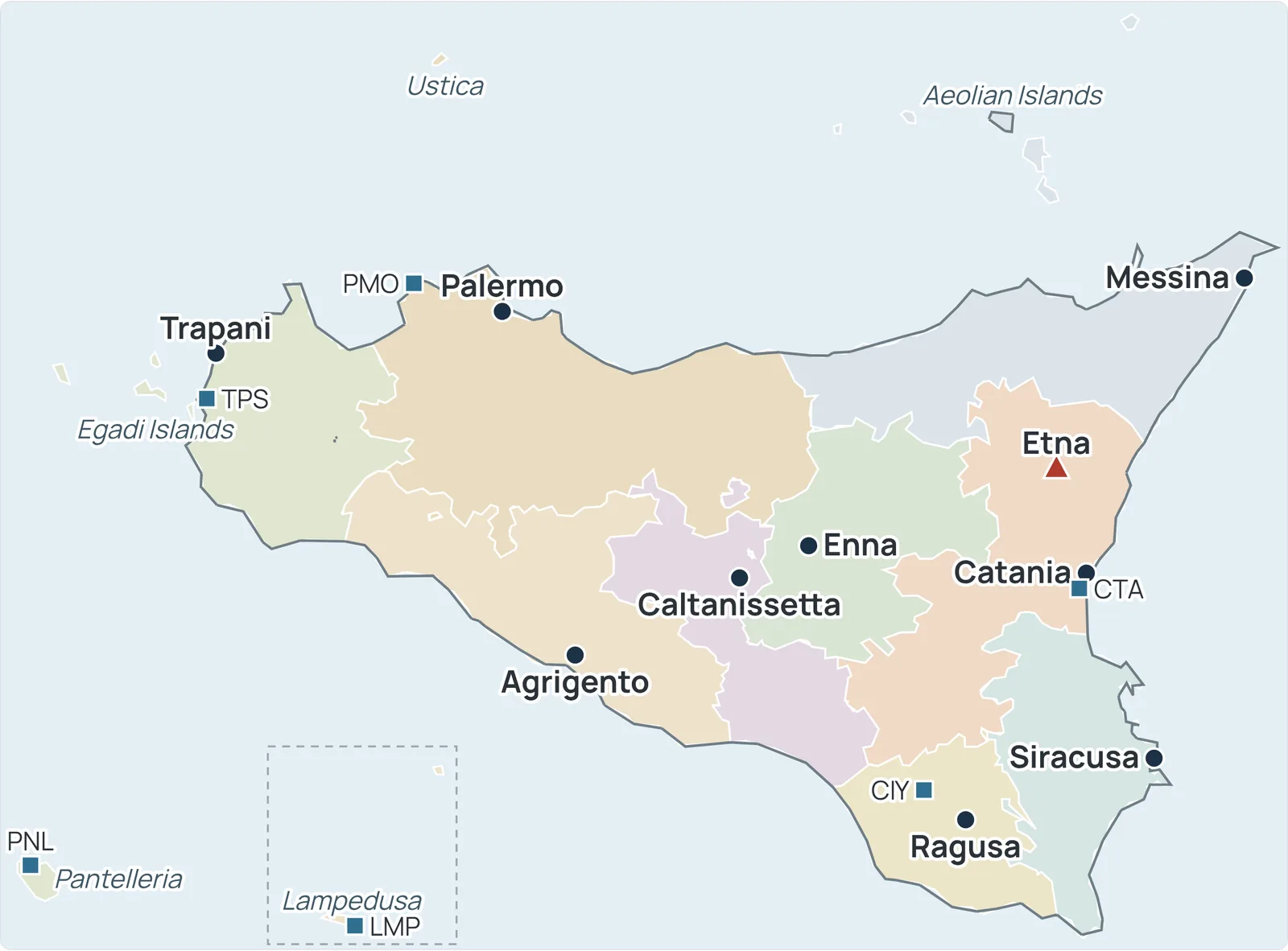
Here is the same map as a single image, with the nine provinces, the provincial capitals, the six airports, Mount Etna and the smaller islands. Save it to your phone before you travel, or print it for planning; for an interactive map with every town, use my Sicily town by town pages.
Frequently asked questions
Where is Sicily located on the map?
In southern Italy, just off the toe of the Italian boot, in the middle of the Mediterranean. The Strait of Messina, about 2 miles (3 km) wide at its narrowest, separates it from Calabria on the mainland. Tunisia is about 100 miles (160 km) to the southwest and Malta about 58 miles (93 km) to the south.
How many provinces are in Sicily?
Nine: Palermo, Catania, Messina, Agrigento, Caltanissetta, Enna, Ragusa, Siracusa and Trapani. Since 2015 Palermo, Catania and Messina are officially metropolitan cities and the other six are free municipal consortia, but they are still widely called provinces.
How big is Sicily compared to a US state?
The region of Sicily covers 9,974 square miles (25,832 km²), a little larger than Vermont (9,616 sq mi) and a little smaller than Massachusetts (10,554 sq mi).
What are the main airports in Sicily?
Palermo (PMO) in the northwest and Catania (CTA) in the east are the main ones. Trapani (TPS) serves the west coast and Comiso (CIY) the southeast, and the islands of Pantelleria (PNL) and Lampedusa (LMP) have their own airports.
How long does it take to drive across Sicily?
From Trapani in the far west to Messina in the northeast is about 207 miles (333 km), roughly 3 hours 40 minutes without traffic. Palermo to Catania is about 130 miles (210 km), roughly two and a half hours.
Which side of Sicily is Mount Etna on?
The east side, just north of Catania and southwest of Taormina. Its summit is about 17 miles (28 km) in a straight line from each.
Which islands are part of Sicily?
The Aeolian Islands (including Lipari, Stromboli and Vulcano), the Egadi Islands (Favignana, Levanzo and Marettimo), the Pelagie Islands (Lampedusa and Linosa), Ustica and Pantelleria.
Sources and small print
- Encyclopaedia Britannica: Sicily (location, the Strait of Messina, distance to Tunisia) and Malta (distance from Sicily)
- ISTAT: La superficie dei comuni, delle province e delle regioni italiane (the area of the region), the list of comuni, and the population of the cities on 31 December 2024 (via Tuttitalia)
- US Census Bureau: State Area Measurements (total area of the four states)
- Assemblea Regionale Siciliana: Statuto della Regione Siciliana (article 1, the islands), and regional law no. 15 of 4 August 2015 on the free municipal consortia and metropolitan cities
- Smithsonian Institution, Global Volcanism Program: Etna (the position of the summit)
- Driving distances and times: Mapbox Directions, without traffic
The maps are drawn from ISTAT's administrative boundaries (openpolis, CC BY 4.0), with every city, airport and island placed from its latitude and longitude: town centres from ISTAT and Wikidata, airports from their published positions.
Credits
Drawing: Operation Sicily®, map data ISTAT via openpolis (CC BY 4.0), all rights reserved, via operationsicily.com.
 The weekly YouTube series