
Is Sicily good for hiking?
Yes, and it is underrated. Most visitors come for temples and beaches and never see the mountains, but Sicily has an active volcano, two large regional mountain parks, a roadless coastal reserve, river gorges and volcanic islands. The trails are quieter than in the Alps or the Dolomites, and you can combine a morning walk with an afternoon by the sea.
The catch is that trail information is patchy, waymarking varies, and summer heat is a real risk on exposed ground. Here is how the main areas compare.
| Area | What it is like | Nearest base | Difficulty |
|---|---|---|---|
| Alcantara Gorges | Basalt gorge you wade through, plus a short riverside path | Taormina | Easy, but icy water |
| Zingaro reserve | Coastal path between coves, no road | Scopello or San Vito Lo Capo | Easy to moderate |
| Mount Etna | Lava fields, old craters, summit area with a guide | Catania or Taormina | Easy to hard |
| Madonie | High peaks, beech woods, mountain villages | Cefalù | Moderate |
| Nebrodi | Sicily's largest park, beech forest, lakes | Cefalù or the north coast | Easy to moderate |
| Stromboli | Active volcano, rules on how high you may go | Stromboli village | Moderate |
Hiking the Alcantara Gorges
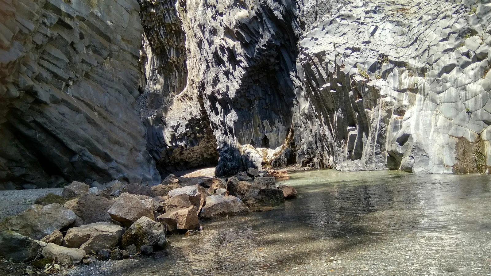
The Alcantara river has cut a gorge through old lava, leaving walls of basalt columns. The river park authority describes the main gorge as about 400 m (a quarter of a mile) long and only a few meters wide, with walls up to 50 m (about 165 ft) high. The gorges sit in contrada Larderia, between Castiglione di Sicilia and Motta Camastra, about 24 km (15 miles) from Taormina, roughly 40 minutes by car, or 58 km (36 miles) from Catania, about 70 minutes.
How to visit
- The municipal access. The town of Motta Camastra runs a long stairway from the SS185 road down to the mouth of the gorges. For 2026 it charges an access contribution of €2 (about $2.20) per person, which also applies at the private entrances; Motta Camastra residents, children under 3 and authorised guides are exempt.
- The private entrances. According to Visit Sicily, the regional tourism site, the private access has lifts down to the river and rents waders.
- From above. Visit Sicily also describes a free municipal access with a view of the gorge from above and a botanical trail, if you do not want to get wet.
When the riverbed allows, you can wade upstream into the gorge. The water is icy even in summer, so this is a hot-weather outing; Visit Sicily recommends spring and summer. In my experience, water shoes and a dry bag for your phone make the difference.
A short walk: the Piccole Gole
The park authority also lists an easy riverside itinerary called the Piccole Gole, the "little gorges", starting at the Ponte di San Nicola. It is about 1 km long with a climb of only 30 m (about 100 ft), past rock pools, small waterfalls and the Cuba Bizantina, a small Byzantine church. It is a nice way to see the river without the crowds of the main gorge.
Hiking the Zingaro Nature Reserve
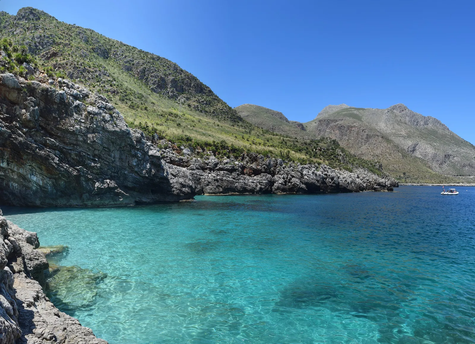
The Zingaro is a stretch of the northwest coast between Scopello and San Vito Lo Capo with paths and coves but no road through it. The reserve has two entrances, one in the south about 1 km from Scopello and one in the north, about 12 km from San Vito Lo Capo. The main path follows the coast between them, and you can drop down to the coves to swim.
It is my favorite walk in the west. Go early, carry more water than you think you need, and wear proper shoes, because the path is rocky. I cover entry, tickets and the coves in my Zingaro Nature Reserve guide, and the beach at the northern end in San Vito Lo Capo beach.
Hiking Mount Etna
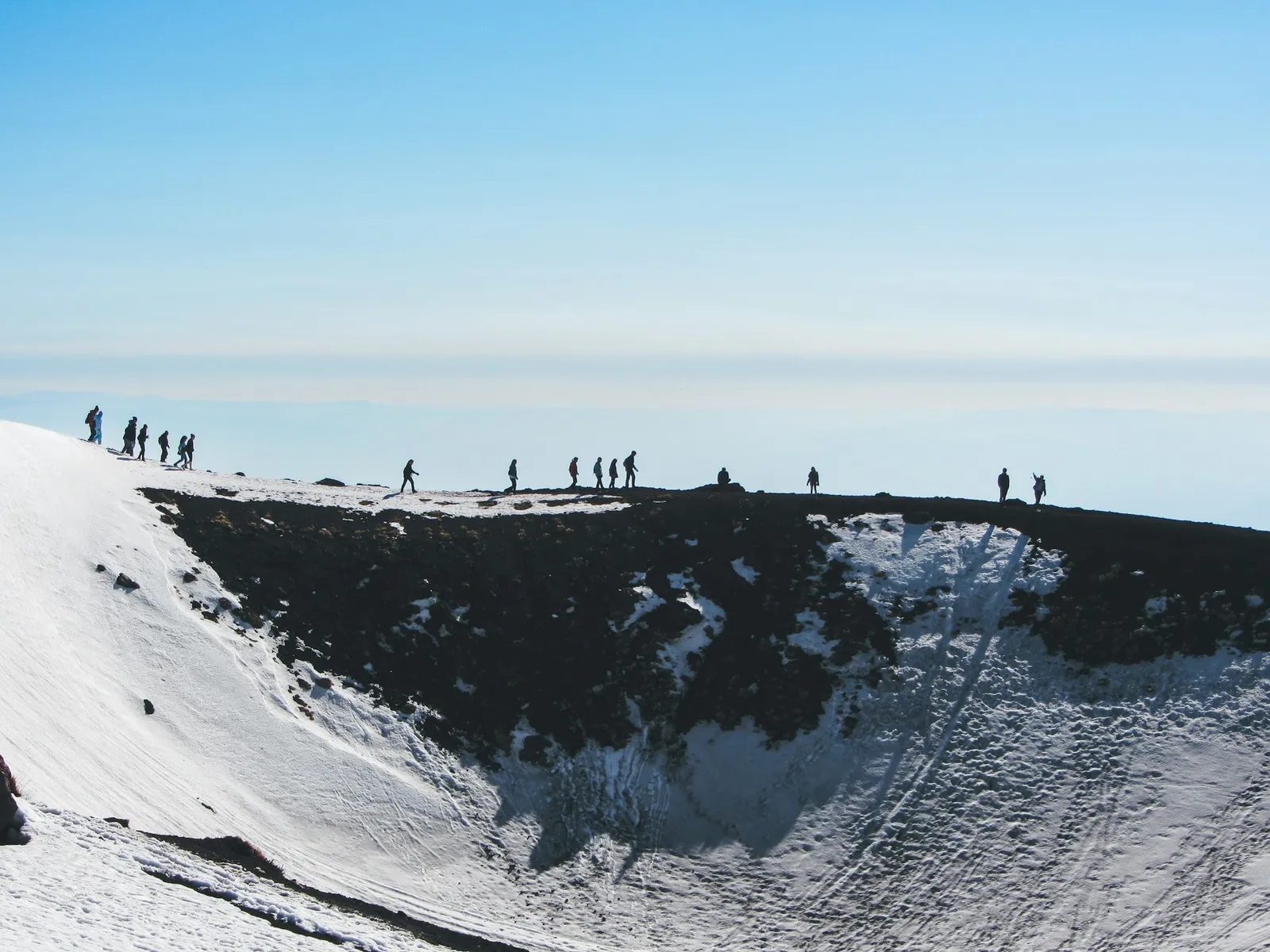
Etna is the highest mountain on any Mediterranean island and, according to UNESCO, the most active stratovolcano in the world; the World Heritage site alone covers 19,237 hectares (about 47,500 acres). It is a different kind of hiking from anywhere else in Sicily: black lava fields, old side craters and, high up, the summit craters.
The short version is that the lower slopes and the Silvestri craters near the Rifugio Sapienza are open to everyone, while the summit area is not: above a set height, hikers must go with an authorised volcano guide, under orders from the local mayors that change with the volcano's activity. I explain the cable car, the bus, the guided tours and the self-guided trails in Mount Etna tours and hikes, and the volcano itself in my Mount Etna guide.
Before any Etna hike, check the current activity with the INGV Osservatorio Etneo, the national volcano institute. Do not rely on a news report or a tour company's website for that.
Hiking in the Madonie mountains
The Madonie rise straight up behind Cefalù, and they are the easiest real mountains to reach from the north coast. The Parco delle Madonie was set up in 1989 and covers 39,941 hectares (about 98,700 acres) across 15 towns, including Cefalù, Castelbuono, Isnello, Polizzi Generosa, Petralia Soprana and Petralia Sottana. It joined the European Geoparks Network in 2001 for its geology, and it is home to the Nebrodi fir, Abies nebrodensis, a tree that survives in the wild with only about 30 individuals.
The classic base for hiking is Piano Battaglia, a high plateau in the territory of Petralia Sottana, between Pizzo Carbonara at 1,979 m (6,493 ft) and Monte Mufara at 1,865 m (6,119 ft). In winter it is Sicily's snowshoe country: Visit Sicily describes snowshoe routes of about four hours that reach Monte Ferro, Monte Mufara, Pizzo Principessa and Pizzo Carbonara. In summer the same area is good for walking among the beech woods.
By car, Piano Battaglia is about 48 km (30 miles) from Cefalù, around 80 minutes, or about 97 km (60 miles) from Palermo, around 1 hour 45 minutes. Castelbuono and the Petralias make lovely places to stay for a night or two; see the Castelbuono and Petralia Sottana town pages.
An easy one: the Rocca di Cefalù
If you are staying in Cefalù and want a short climb, the Rocca above the town rises 270 m (about 890 ft) above the sea, with the remains of a castle and the so-called Temple of Diana on the way. The town charges about €5 ($5.50) for the walk, and it is a good hour or two in the cooler part of the day. More in things to do in Cefalù.
Hiking in the Nebrodi mountains
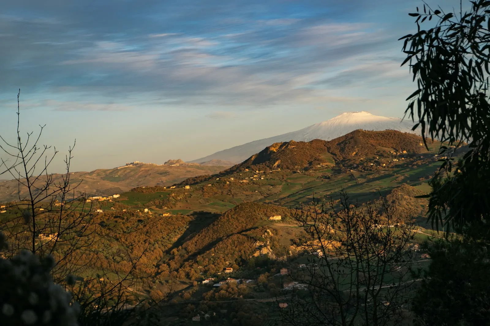
East of the Madonie, the Nebrodi are gentler, greener and much less visited. The Parco dei Nebrodi was set up in 1993 and, at about 86,000 hectares (about 212,500 acres), it is the largest regional park in Sicily. Its highest peak is Monte Soro at 1,847 m (6,060 ft), and its woods are dominated by beech. The crags of the Rocche del Crasto reach 1,315 m (4,314 ft).
The park is a place for long, easy walks rather than dramatic summits: forest tracks, high pastures and small mountain lakes. The Biviere di Cesarò and Urio Quattrocchi are among the protected wetland sites in the park. The town of Cesarò is one of the gateways from the Etna side. You need a car here, and the roads are slow, so plan on staying a night in the mountains rather than driving in and out from the coast.
Hiking near Syracuse: Pantalica, Cavagrande and Vendicari
The southeast has some of the best walking on the island, and it pairs well with a stay in Syracuse and Ortigia or the baroque towns around Noto.
Pantalica and the Anapo valley
Pantalica is part of the same UNESCO World Heritage site as Syracuse: a plateau ringed by canyons cut by the Anapo and Calcinara rivers, with thousands of tombs carved into the rock. You can go in from the Ferla side or the Sortino side. For the archaeology, start from Ferla, where the Giarranauti path passes the necropolis, the so-called prince's palace (the anaktoron) and rock-cut oratories. For an easy walk, take the path along the Anapo valley, mainly flat and about 13 km (8 miles) long, which follows the route of an old railway, tunnels included.
Cavagrande del Cassibile
Between Avola, Noto and Syracuse, the Cassibile river has cut a deep canyon, with waterfalls and small lakes where you can cool off. Visit Sicily says the regional forestry agency keeps only three paths regularly open. The most used, the Scala Cruci, drops from the viewpoint at Avola Antica to the lakes; the Carrubella is a loop of about 6 km (3.7 miles) with a height difference of about 180 m (590 ft). Whatever goes down must come back up, so start early in summer, and check access with the forestry agency, the Azienda Foreste Demaniali, before you go.
Vendicari
On the coast near Noto, the Vendicari reserve is a walk among dunes, lagoons and an old tuna fishery, and Visit Sicily says it is easy to spot herons, storks and flamingos there.
Hiking Stromboli and the Aeolian Islands
Stromboli is one of the best-known volcano hikes in Europe, and also one of the most regulated. The rules are set by orders from the mayor of Lipari, which change with the volcano's activity. Under the order of 5 May 2025, published by the INGV's Aeolian monitoring center:
- you may climb on your own up to 290 m (951 ft), on the set paths from the village;
- between 290 m and 400 m (1,312 ft), you may only go with an authorised alpine or volcano guide, with at most 25 people per guide;
- above 290 m, a helmet and a mask are required;
- from Ginostra, on the other side of the island, you may climb on your own to 130 m, and with a guide to 400 m on the Punta Corvi trail.
These limits can change at short notice, so check the latest order on the INGV page before you go, and treat any tour that promises the summit with caution. The island is reached by hydrofoil, mainly from Milazzo.
The other Aeolian Islands have gentler walks along their coasts and old mule tracks. On Vulcano, the classic is the climb to the rim of the Gran Cratere, when access is open. My Aeolian Islands guide covers all seven, and volcanoes in Sicily explains Stromboli and Vulcano and where to check their current status.
After the walk: snorkeling and diving
Sicily's sea is as good a reason to come as its mountains, and two places stand out for divers. Ustica, an island north of Palermo, was Italy's first marine protected area, created in 1986, according to the official Italian tourism site. Off Trapani, the Egadi Islands marine reserve covers about 54,000 hectares (about 133,400 acres) around Favignana, Levanzo and Marettimo; National Geographic Italia calls it the largest marine reserve in Italy and says it protects the most extensive and best preserved meadow of Posidonia seagrass in the Mediterranean.
Both have local dive centers that run trips in season. For the Egadi, my island-hopping guide explains the ferries, and Cala Rossa is the best-known snorkeling cove on Favignana.
When to hike in Sicily and what to bring
The best hiking months are spring, roughly March to June, and fall, September to November. Summer is fine for the Alcantara Gorges and high up on Etna, Stromboli in the evening or the Madonie woods, but long exposed walks like the Zingaro are hard work in July and August. Winter brings snow to Etna and the Madonie, which is great for snowshoeing but needs proper gear. My best time to visit Sicily guide and the month-by-month planner below give the detail.
- Water. More than you think. There are few sources on the trails.
- Sun protection. A hat and sunscreen, even in spring.
- Shoes. Hiking shoes for Zingaro, Etna and the mountains; water shoes for the Alcantara.
- A layer. Etna and the Madonie are much colder than the coast.
- A car. Most trailheads are not on a bus route; see renting a car in Sicily.
For where to base yourself, see where to stay in Sicily; for everything else to see on the island, the best things to do in Sicily.
Frequently asked questions
Is Sicily good for hiking?
Yes. Sicily has Mount Etna, the Madonie and Nebrodi mountain parks, the Zingaro coastal reserve, the Alcantara Gorges and the volcano trails of Stromboli. The trails are quiet, and spring and fall are the best seasons.
What is the best hike in Sicily?
For most visitors, the coastal path through the Zingaro reserve between Scopello and San Vito Lo Capo. For a volcano, a guided hike in the summit area of Etna or the climb on Stromboli within the current limits. For mountains, the area around Piano Battaglia in the Madonie.
Can you hike the Alcantara Gorges?
Yes. You go down a stairway or take the lift at a private entrance, then wade upstream into the gorge when the riverbed allows. The water is icy, so it is best in summer. There is also an easy 1 km riverside walk, the Piccole Gole, and a free viewpoint from above.
Can you hike Etna on your own?
Yes, on the lower slopes and the Silvestri craters near the Rifugio Sapienza. Above a set height in the summit area, you must go with an authorised guide under the local mayors' orders, which change with the volcano's activity.
Can you hike Stromboli without a guide?
Only part of the way. Under the Lipari mayor's order of May 2025, you can climb on your own to 290 m; from 290 m to 400 m you must go with an authorised guide, with a helmet and mask. The rules change, so check the latest order before you go.
When is the best time to hike in Sicily?
Spring, roughly March to June, and fall, September to November. Summer is too hot for long exposed hikes, though the Alcantara Gorges are at their best then. Winter brings snow to Etna and the Madonie.
Is there snow in Sicily?
Yes, in winter on Mount Etna and in the Madonie mountains. Piano Battaglia in the Madonie is the place for snowshoeing, with routes of around four hours to the surrounding peaks.
Where can you go diving in Sicily?
Ustica, north of Palermo, which was Italy's first marine protected area, and the Egadi Islands off Trapani, whose marine reserve is the largest in Italy. Both have dive centers that run trips in season.
Sources and small print
- Parco Fluviale dell'Alcantara, the gorges, and its Piccole Gole itinerary
- Comune di Motta Camastra, access to the Alcantara Gorges and the 2026 contribution
- Visit Sicily (Regione Siciliana), the Alcantara Gorges, snowshoeing at Piano Battaglia and Monte Soro
- Riserva Naturale Orientata dello Zingaro, the entrances
- Regione Siciliana, regional parks office: Parco delle Madonie and Parco dei Nebrodi
- Comune di Lipari, order no. 16 of 5 May 2025, on climbing Stromboli, as published by the INGV Centro Monitoraggio Eolie
- UNESCO World Heritage Centre, Mount Etna, and the INGV Osservatorio Etneo for its current activity
- italia.it, the Ustica marine protected area, and National Geographic Italia on the Egadi Islands reserve
- Comune di Cefalù, the Rocca
- Visit Sicily (Regione Siciliana): Pantalica, trekking in Cavagrande del Cassibile and the Vendicari reserve, with the UNESCO World Heritage Centre on Syracuse and Pantalica
Driving times are measured on the road network without traffic and rounded. Rules for Etna and Stromboli change with the volcanoes, so always check the current order before you go.
Credits
Photo: Carlo Alberto Burato, Unsplash Licence, via Unsplash.
Photo: The Cosmonaut, CC BY-SA 4.0, via Wikimedia Commons.
Photo: Casey Lovegrove, Unsplash Licence, via Unsplash.
Photo: Sander Sammy, Unsplash Licence, via Unsplash.
 The weekly YouTube series