
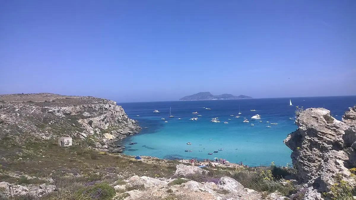
About Cala Rossa, Favignana
Cala Rossa sits at the north eastern tip of Favignana, the largest of the Egadi islands off Trapani. The coast here was worked for tuff, the soft golden calcarenite used to build much of western Sicily, and the quarrying left the cove ringed by square cuts, stepped ledges and small caves. There is no beach in the usual sense: a little sand collects between the rocks, but people spread their towels on the flat stone.
The water is the reason people come. It shades from deep blue to pale turquoise over a rocky and sandy seabed and is usually very clear, which makes it one of the best snorkelling spots on the island. It gets deep quite quickly off the ledges, so it suits swimmers more than small children. On a clear day the island of Levanzo fills the view across the bay.
The name means red cove. The local story links it to the Battle of the Egadi in 241 BC, which ended the First Punic War: the Roman fleet under Lutatius Catulus sank or captured dozens of Carthaginian ships off these islands, and legend says the blood of the dead coloured the water of this bay red. It is a legend, but the battle itself is real history.
Cala Rossa faces north, so it is at its calmest when the Scirocco blows from the south east and can be rough under a northerly. Boats on day trips from Trapani stop here, and in July and August the bay can be busy both on the rocks and on the water.
How to get to Cala Rossa, Favignana
Favignana is reached by hydrofoil or ferry from Trapani, and from Marsala in season. From the harbour, most people cycle or take a scooter east out of the town and follow the signs for Cala Rossa, which is a few kilometres away. The road climbs to the higher ground above the quarries, where you leave the bike.
From there a short but steep path drops down through the quarry cuts to the water, taking 10 to 15 minutes. The rock is sharp and can be slippery, so wear shoes with straps or rock shoes rather than flip flops. You can also see the cove from the sea on one of the many boat trips round the island.
Ride or drive to the top of the old quarries, then walk 10 to 15 minutes down a steep, uneven path over sharp tuff rock.
Cala Rossa, Favignana is on one of Sicily’s small islands: see the Favignana town page for ferries, hydrofoils and flights.
Tips for visiting Cala Rossa, Favignana
- Bring water, food and shade: there are no services on the rocks.
- Wear rock shoes for the path and for getting in and out of the water.
- Go early in the morning in July and August, before the boats and the crowds arrive.
- Choose Cala Rossa on days with a southerly wind; with a northerly, head to the south coast instead.
- Nearby Bue Marino has the same quarry scenery and is usually quieter.
What is there
- No lidos or sunbed hire, with a free public stretch.
- Inside the Area Marina Protetta Isole Egadi: follow the reserve’s rules on access, fires, dogs and taking sand or shells.
Water quality at Cala Rossa, Favignana
The nearest official monitoring point, Calarossa, was rated excellent for bathing in the 2025 season under the EU Bathing Water Directive, as it has been in each of the last 11 seasons.
- 2025Excellent
- 2024Excellent
- 2023Excellent
- 2022Excellent
- 2021Excellent
- 2020Excellent
- 2019Excellent
- 2018Excellent
Ratings run from excellent through good and sufficient to poor, and are set from four seasons of samples taken through each bathing season by the Italian health authorities and reported to the European Environment Agency.
Facts about Cala Rossa, Favignana
- The cove is ringed by old tuff quarries, the stone that built much of western Sicily.
- Its name is tied by legend to the Battle of the Egadi in 241 BC, which ended the First Punic War.
- The island of Levanzo lies across the bay on the horizon.
- Cala Rossa lies within the Egadi Islands Marine Protected Area.
Favignana: the town
Favignana is the island comune of the Egadi archipelago, about 18 km off the coast between Trapani and Marsala, covering Favignana, Levanzo and Marettimo with about 4,500 residents, and one of the few places in Sicily that is growing. Read our guide to living in Favignana: house prices, the weather month by month, the nearest hospital and airports, history and food.
Beaches near Cala Rossa, Favignana
- Bue Marino Favignana, under 1 km, rocks
- Cala Azzurra Favignana, 1 km, sand and rocks
- Lido Burrone Favignana, 2 km, fine sand
- Calamoni Beach Favignana, 3 km, sand and rocks
- Praia Beach Favignana, 3 km, fine sand
- Cala del Pozzo Favignana, 6 km, sand and rocks
- Cala Rotonda Favignana, 7 km, sand and rocks
- Cala Faraglione Favignana, 8 km, rocks and pebbles
Frequently asked questions
Is Cala Rossa sandy?
No. Cala Rossa is a rocky cove. A little sand gathers between the rocks, but you sunbathe on flat tuff ledges left by the old quarries and get into the water from the rock. Rock shoes make it much easier.
Is Cala Rossa good for children?
It is tricky with small children. The path down is steep and uneven, there is no shade or bar, and the water gets deep close to the rocks. Older children who swim well love it; families with toddlers usually find Cala Azzurra or Lido Burrone easier.
How do you get to Cala Rossa from Favignana port?
Hire a bike or scooter in the town and follow the signs east to Cala Rossa, a few kilometres away. Leave it at the top above the quarries and walk down the steep path for 10 to 15 minutes. Many boat trips also stop in the bay.
Why is it called Cala Rossa?
Cala Rossa means red cove. Local legend says the sea here was coloured red by the blood of the Carthaginians killed in the Battle of the Egadi in 241 BC, the sea battle that ended the First Punic War.
Is the water clean at Cala Rossa, Favignana?
The nearest official monitoring point, Calarossa, was rated excellent for bathing in the 2025 season under the EU Bathing Water Directive, as it has been in each of the last 11 seasons. Ratings are based on samples taken through the bathing season and checked for bacteria from sewage. After heavy rain, water near river mouths can be cloudy for a day or two.
Featured in
Credits
Photo: Arcona B&B, CC BY 3.0, via Wikimedia Commons.
Written from 5 or more independent sources and checked. Figures: bathing water quality from the European Environment Agency (EU Bathing Water Directive), drive times and facilities from © OpenStreetMap contributors, map boundaries ISTAT via openpolis (CC BY 4.0).
Before you go: the latest sampling results and any bathing bans are on the Ministry of Health's Portale Acque, and local notices on the comune of Favignana's website.
 The weekly YouTube series