
About Capo Mulini
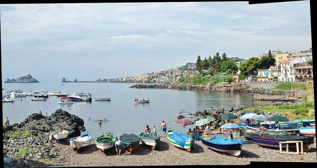
Capo Mulini is a frazione of Acireale, about 5 kilometres south of the town, built on the cape that marks the northern edge of the Gulf of Catania. Its landmark is the Torre di Sant'Anna, a coastal watchtower begun in 1582 to spot pirate ships and now working as a lighthouse. Below it the shore is black lava rock, broken by the small harbour where fishing boats still tie up.
Swimming here is from the rocks below the lighthouse and along the shore by the harbour, either on free shelves of lava or from the decks of a handful of lidos. The sea is deep and clear, and on calm days the rock edges are good for snorkelling. It is calmer and less built up than the seafront at Aci Trezza, just to the south.
The village's living comes from fishing, restaurants and summer visitors, and the bay is lined with places serving the day's catch. In the nineteenth century there were plans for a large commercial harbour here, which were dropped in favour of Catania. Drawbacks are the usual ones on this coast: sharp rock, no natural shade and limited parking in August.
How to get to Capo Mulini
Capo Mulini lies between Aci Trezza and Acireale. Take the SS114 coast road and turn down to the sea, or continue along the coast from Aci Trezza. Parking is on the streets of the village and near the harbour, and it fills on summer weekends and evenings when the restaurants are busy.
From the parking areas it is a few minutes on foot to the rocks.
From the village and its small harbour, short steps and paths lead down to the lava rocks and lido decks.
By car, Capo Mulini is about 29 minutes from Catania Fontanarossa airport and 1 hour 56 minutes from Comiso airport.
Tips for visiting Capo Mulini
- Bring water shoes for the lava rocks and ladders.
- Come for a late afternoon swim and stay for fish in the village.
- On calm days snorkel along the rocks below the lighthouse.
- Bring your own shade if you use the free rocks.
What is there
- Lidos with sunbeds and umbrellas to rent, with a free public stretch.
- 5 public car parks mapped within 600 metres; in July and August they fill early.
Water quality at Capo Mulini
The nearest official monitoring point, Capo Mulini-Sbocco Via Gurne, 20 M Sud, was rated excellent for bathing in the 2025 season under the EU Bathing Water Directive, as it has been in each of the last 11 seasons.
- 2025Excellent
- 2024Excellent
- 2023Excellent
- 2022Excellent
- 2021Excellent
- 2020Excellent
- 2019Excellent
- 2018Excellent
Ratings run from excellent through good and sufficient to poor, and are set from four seasons of samples taken through each bathing season by the Italian health authorities and reported to the European Environment Agency.
Facts about Capo Mulini
- The Torre di Sant'Anna was begun in 1582 as a watchtower against corsairs and is now a lighthouse.
- The cape marks the northern limit of the Gulf of Catania.
- A large commercial port was planned here in the nineteenth century but was built in Catania instead.
- Capo Mulini is about 5 kilometres south of Acireale.
Acireale: the town
Acireale is a baroque city of about 50,600 people on a lava terrace above the Ionian Sea, between Catania and Etna, best known for one of Italy's great carnivals and for taking its granita very seriously. Read our guide to living in Acireale: house prices, the weather month by month, the nearest hospital and airports, history and food.
Beaches near Capo Mulini
- Aci Trezza Aci Castello, 2 km, rocks
- Aci Castello Aci Castello, 3 km, rocks
- Santa Maria la Scala Acireale, 4 km, rocks and pebbles
- Santa Tecla Acireale, 6 km, rocks
- San Giovanni Li Cuti Beach Catania, 9 km, sand and rocks
- Pozzillo Beach Acireale, 9 km, rocks and pebbles
- Praiola Beach Riposto, 11 km, pebbles
- La Playa di Catania Catania, 14 km, fine sand
Frequently asked questions
Is Capo Mulini a sandy beach?
No. Capo Mulini is lava rock, like the rest of the Riviera dei Ciclopi. You swim from rock shelves around the bay and below the lighthouse, or from lido decks. Bring water shoes and something soft to lie on.
What is there to do at Capo Mulini apart from swimming?
Walk out to the old Torre di Sant'Anna, now a lighthouse, watch the fishing boats in the little harbour, and eat at one of the seafood restaurants around the bay. Aci Trezza and its Cyclops rocks are just down the coast.
Is Capo Mulini quieter than Aci Trezza?
Generally, yes. It is a small fishing village with fewer lidos and less traffic than the seafront at Aci Trezza, although the restaurants make it lively on summer evenings and weekends.
Is the water clean at Capo Mulini?
The nearest official monitoring point, Capo Mulini-Sbocco Via Gurne, 20 M Sud, was rated excellent for bathing in the 2025 season under the EU Bathing Water Directive, as it has been in each of the last 11 seasons. Ratings are based on samples taken through the bathing season and checked for bacteria from sewage. After heavy rain, water near river mouths can be cloudy for a day or two.
Featured in
Credits
Photo: andrea, CC BY-SA 2.0, via Wikimedia Commons.
Written from 3 or more independent sources and checked. Figures: bathing water quality from the European Environment Agency (EU Bathing Water Directive), drive times and facilities from © OpenStreetMap contributors, map boundaries ISTAT via openpolis (CC BY 4.0).
Before you go: the latest sampling results and any bathing bans are on the Ministry of Health's Portale Acque, and local notices on the comune of Acireale's website.
 The weekly YouTube series