
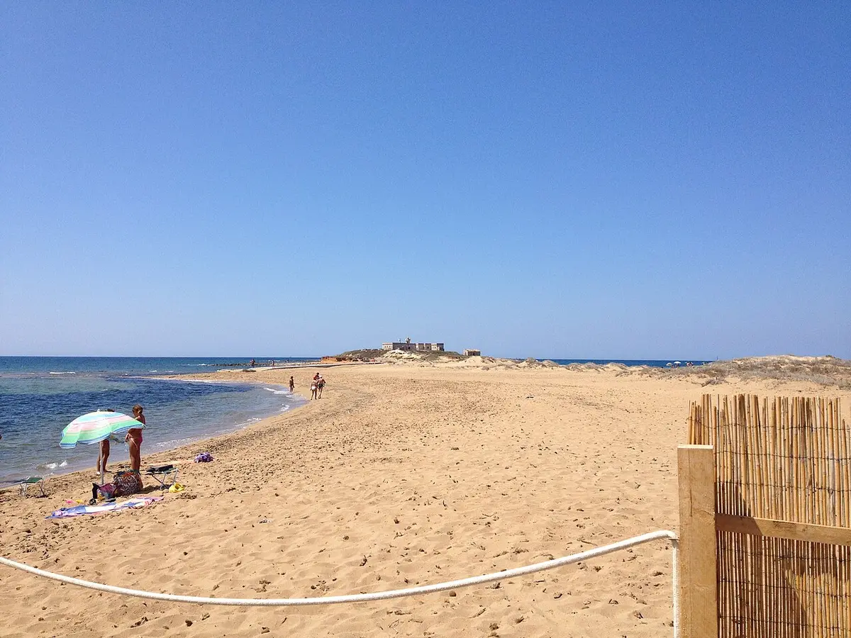
About Isola delle Correnti Beach
The Isola delle Correnti, the Island of the Currents, is a low, round islet of about 10,000 square metres, rising no more than four metres above the sea. It marks the southern point of Sicily, further south than Tunis, and the currents of the Ionian and the Mediterranean meet around it, which is where it gets its name.
Facing it on the mainland is a beach of fine golden sand of around 700 metres, backed by dunes shaped by the wind. Part of it is free and part is taken by lidos renting umbrellas and sunbeds. The sea is clear, and the constant meeting of currents and wind gives it shifting colours.
The island is joined to the shore by an artificial causeway of stones that storms have broken several times. At low water it becomes a peninsula you can reach on foot, wading over rock with the currents pulling, which should only be attempted in calm, windless conditions and with shoes for the rocks.
On the island stands a lighthouse first lit in 1865, now disused, beside the empty houses of the keeper's family; the working light is a modern tower beside it. A statue of Christ the Redeemer, placed in 2019, carries the words southernmost point of Italy and the names of both seas. The island has been included in the regional plan of parks and reserves since 1987 for its coastal plants.
How to get to Isola delle Correnti Beach
From Pachino or Portopalo di Capo Passero follow the signs for the Isola delle Correnti along the SP8. The last stretch of road is unsurfaced and ends at a large car park only a few steps from the beach.
Both the car park and the beach fill in the hour before sunset in summer, when people come to watch the sun go down over the two seas.
A dirt road ends at a large car park a few steps from the sand.
By car, Isola delle Correnti Beach is about 1 hour 44 minutes from Catania Fontanarossa airport and 1 hour 50 minutes from Comiso airport.
Tips for visiting Isola delle Correnti Beach
- Only cross to the island in calm weather with no wind, and wear rock shoes.
- Do not enter the old lighthouse buildings, which are disused and decaying.
- Arrive an hour before sunset to get a parking space.
- Bring water and an umbrella in case the lidos are closed.
- Kitesurfing conditions are best outside midsummer.
What is there
- Lidos with sunbeds and umbrellas to rent, with a free public stretch.
- Toilets or showers mapped within 400 metres.
- 3 public car parks mapped within 600 metres; in July and August they fill early.
Water quality at Isola delle Correnti Beach
The nearest official monitoring point, Guardiana-Captain Camping, was rated excellent for bathing in the 2025 season under the EU Bathing Water Directive, as it has been in each of the last 11 seasons.
- 2025Excellent
- 2024Excellent
- 2023Excellent
- 2022Excellent
- 2021Excellent
- 2020Excellent
- 2019Excellent
- 2018Excellent
Ratings run from excellent through good and sufficient to poor, and are set from four seasons of samples taken through each bathing season by the Italian health authorities and reported to the European Environment Agency.
Facts about Isola delle Correnti Beach
- The Isola delle Correnti is the southernmost point of Sicily, further south than Tunis.
- The island covers about 10,000 square metres and rises no more than four metres above the sea.
- Its lighthouse was first lit in 1865 and is no longer in use.
- A statue of Christ the Redeemer placed in 2019 names both the Ionian and the Mediterranean.
- The island has been part of the regional plan of parks and reserves since 1987.
Portopalo di Capo Passero: the town
Portopalo di Capo Passero is the southernmost comune on the island of Sicily, a fishing town of about 3,900 people where the Ionian Sea meets the Strait of Sicily, further south than Tunis. Read our guide to living in Portopalo di Capo Passero: house prices, the weather month by month, the nearest hospital and airports, history and food.
Beaches near Isola delle Correnti Beach
- Carratois Beach Pachino, 2 km, fine sand
- Scalo Mandrie Beach Portopalo di Capo Passero, 7 km, sand and rocks
- Morghella Beach Pachino, 7 km, sand
- Granelli Beach Pachino, 9 km, fine sand
- Porto Ulisse Beach Ispica, 10 km, sand and rocks
- Punta Ciriga Beach Ispica, 11 km, sand and rocks
- Spinazza Beach Noto, 11 km, fine sand
- San Lorenzo Beach Noto, 13 km, fine sand
Frequently asked questions
Can you walk to the Isola delle Correnti?
At low water, yes: a rocky causeway links it to the beach and you can wade across. The currents are strong, the rocks are slippery and the crossing can be up to waist deep, so only try it on a calm, windless day with rock shoes, and never with small children.
Do the Ionian and Mediterranean meet at the Isola delle Correnti?
Yes, that is the island's claim to fame and the origin of its name. The currents of the two seas meet around the islet, and a statue placed there in 2019 names both seas and calls the spot the southernmost point of Italy.
Is Isola delle Correnti Beach good for kitesurfing?
Yes. It is an exposed, windy spot used by kitesurfers and windsurfers through much of the year, though conditions suit experienced riders best. In summer the wind is often lighter, while spring, autumn and winter bring stronger breezes.
Is there parking at the Isola delle Correnti?
Yes, a large car park at the end of an unsurfaced road, a few steps from the sand. It fills up in summer in the hour before sunset, when the beach is at its busiest.
Is the water clean at Isola delle Correnti Beach?
The nearest official monitoring point, Guardiana-Captain Camping, was rated excellent for bathing in the 2025 season under the EU Bathing Water Directive, as it has been in each of the last 11 seasons. Ratings are based on samples taken through the bathing season and checked for bacteria from sewage. After heavy rain, water near river mouths can be cloudy for a day or two.
Is Isola delle Correnti Beach sandy?
Yes, Isola delle Correnti Beach is a golden sand beach.
Featured in
Credits
Photo: Andrea Tomasello, CC BY-SA 3.0, via Wikimedia Commons.
Written from 6 or more independent sources and checked. Figures: bathing water quality from the European Environment Agency (EU Bathing Water Directive), drive times and facilities from © OpenStreetMap contributors, map boundaries ISTAT via openpolis (CC BY 4.0).
Before you go: the latest sampling results and any bathing bans are on the Ministry of Health's Portale Acque, and local notices on the comune of Portopalo di Capo Passero's website.
 The weekly YouTube series