
About Scala dei Turchi
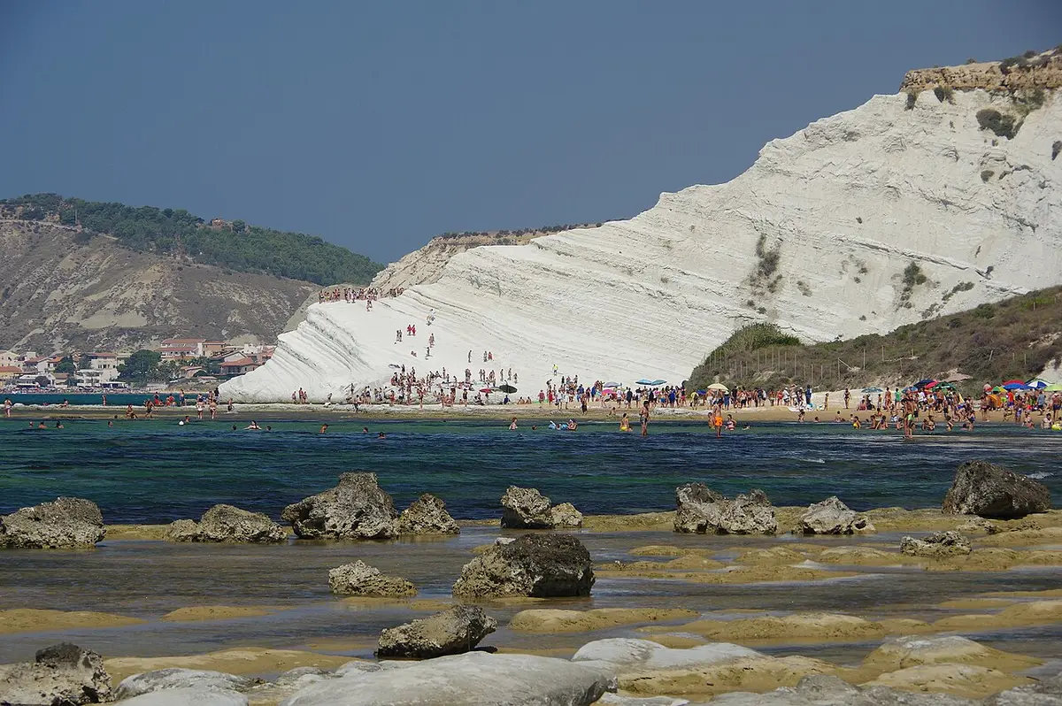
The cliff is made of white marl, a soft sedimentary rock of clay and calcium carbonate full of the shells of tiny marine organisms. Geologists place it in the Trubi Formation of the Lower Pliocene, laid down after the Mediterranean refilled at the end of the Messinian salinity crisis. The pale horizontal bands you can see in the terraces record regular cycles in the Earth's orbit, which is why the rock is studied as well as photographed.
Wind, rain and waves wear the marl into smooth, rounded ledges that look like a giant staircase, and that shape gave the place its name. The Turks of the name were the Saracen and Barbary raiders who once landed along this coast; local tradition holds that the sheltered bay below the cliff made a convenient place to come ashore. The cliff sits between two long stretches of golden sand, so you can walk along the shore and see it from both sides.
Fame has been hard on the site. After years of complaints about erosion and visitors carving and littering the rock, prosecutors in Agrigento seized the cliff in 2020, and free walking or lying on the white marl has been forbidden ever since. The comune has since reopened and closed the area more than once by ordinance, at times with a ticket and a cap on numbers, so what you find on the day depends on the latest decision. You can always see it from the viewpoint on the coast road above.
Andrea Camilleri wrote the cliff into his Inspector Montalbano stories, and that, more than anything, turned it from a local swimming spot into one of the most photographed places in Sicily. In 2007 the comune of Realmonte asked UNESCO to list the cliff together with the nearby Roman villa; it has not been inscribed.
How to get to Scala dei Turchi
From Agrigento take the SS115 west towards Porto Empedocle and Realmonte, then the coast road towards Realmonte, which runs above the cliff. Several paid car parks line the road in summer and there is a viewpoint at the top; do not leave the car on the verges, where fines and towing are common.
From the eastern side a steep path and steps lead down to the beach, a few minutes on foot, though it is awkward for older people and small children. You can also walk along the shore from Lido Rossello to the west, about 2 kilometres over sand and low rocks that can be tricky at high tide.
A steep path and steps lead down from the coast road to the sand at the foot of the cliff; climbing on the white marl itself is banned and the site has at times been fenced off by the comune.
By car, Scala dei Turchi is about 2 hours 18 minutes from Catania Fontanarossa airport and 2 hours 28 minutes from Comiso airport.
Tips for visiting Scala dei Turchi
- Check whether the site is open before you set off; closures by ordinance come and go.
- Come early in the morning or towards sunset, when the light on the white rock is softer and the crowds thinner.
- Do not climb, carve or take marl from the cliff; it is forbidden and fines are enforced.
- There is no shade on the sand, so bring a hat and plenty of water.
- For the classic view without the walk down, stop at the viewpoint on the coast road above the cliff.
What is there
- Lidos: check locally, with a free public stretch.
- 4 public car parks mapped within 600 metres; in July and August they fill early.
Water quality at Scala dei Turchi
The nearest official monitoring point, Punta Grande, was rated excellent for bathing in the 2025 season under the EU Bathing Water Directive, as it has been in each of the last 11 seasons.
- 2025Excellent
- 2024Excellent
- 2023Excellent
- 2022Excellent
- 2021Excellent
- 2020Excellent
- 2019Excellent
- 2018Excellent
Ratings run from excellent through good and sufficient to poor, and are set from four seasons of samples taken through each bathing season by the Italian health authorities and reported to the European Environment Agency.
Facts about Scala dei Turchi
- The cliff belongs to the Trubi Formation, white marl laid down in the Lower Pliocene after the Mediterranean refilled.
- Its banding records orbital cycles, which makes it a site of interest to geologists studying past climate.
- The name refers to the Saracen and Barbary raiders, called Turks by local people, who landed on this coast.
- Andrea Camilleri set scenes in his Montalbano novels here.
- Realmonte applied for UNESCO World Heritage status for the cliff and the nearby Roman villa in 2007.
Realmonte: the town
Realmonte is a coastal town of about 4,300 people just west of Porto Empedocle, home to the Scala dei Turchi, the white marl cliff that falls to the sea in great natural steps. Read our guide to living in Realmonte: house prices, the weather month by month, the nearest hospital and airports, history and food.
Beaches near Scala dei Turchi
- Capo Rossello Beach Realmonte, 2 km, sand
- Giallonardo Beach Realmonte, 6 km, sand
- San Leone Beach Agrigento, 10 km, fine sand
- Siculiana Marina Beach Siculiana, 10 km, sand
- Torre Salsa Beach Siculiana, 13 km, sand
- Punta Bianca Beach Agrigento, 19 km, sand and pebbles
- Cala Vincenzina Palma di Montechiaro, 21 km, sand
- Eraclea Minoa Beach Cattolica Eraclea, 22 km, fine sand
Frequently asked questions
Can you still walk on the Scala dei Turchi?
Only on a booked visit. Since 2025 the comune of Realmonte has reopened part of the promontory with controlled access, a paid ticket and a cap on numbers, booked through the comune's My Scala dei Turchi page. Climbing freely or lying on the white marl is still banned. You can always admire it from the sand at its foot, from the sea or from the viewpoint on the coast road.
Is there a beach at the Scala dei Turchi?
Yes. Long stretches of golden sand run along the shore on both sides of the cliff, and you reach them by a steep path from the coast road or by walking along the shore from Lido Rossello. The sand below the cliff has no shade, so bring your own.
Why is it called the Turkish Steps?
The rounded terraces of white marl look like a staircase, and Turks was the local name for the Saracen and Barbary pirates who raided this coast. Tradition says they used the sheltered bay beside the cliff as a landing place.
How do you get to the Scala dei Turchi from Agrigento?
Drive west on the SS115 towards Porto Empedocle and Realmonte, then follow the coast road towards Realmonte, which passes above the cliff. Use one of the paid car parks along the road and walk down the path and steps to the beach.
Is the water clean at Scala dei Turchi?
The nearest official monitoring point, Punta Grande, was rated excellent for bathing in the 2025 season under the EU Bathing Water Directive, as it has been in each of the last 11 seasons. Ratings are based on samples taken through the bathing season and checked for bacteria from sewage. After heavy rain, water near river mouths can be cloudy for a day or two.
Is Scala dei Turchi sandy?
Yes, Scala dei Turchi is a golden sand beach.
Featured in
Credits
Photo: Spatuzzi Bruno, CC BY-SA 4.0, via Wikimedia Commons.
Written from 5 or more independent sources and checked. Figures: bathing water quality from the European Environment Agency (EU Bathing Water Directive), drive times and facilities from © OpenStreetMap contributors, map boundaries ISTAT via openpolis (CC BY 4.0).
Before you go: the latest sampling results and any bathing bans are on the Ministry of Health's Portale Acque, and local notices on the comune of Realmonte's website.
 The weekly YouTube series